Civil 3D

Autodesk Civil 3D
Introduction to Civil 3D
Civil 3D is a powerful design and documentation software for infrastructure projects, offering tools to streamline transportation, grading, and site development. The training consists of two specialized modules: Civil 3D for Highway Designing and Civil 3D for Pipe Network Designing.
These courses are designed for civil engineers and drafters to enhance their skills. With numerous upcoming government projects in India, Civil 3D will be crucial for accurate design and compliance with national standards. It is also valuable for non-government infrastructure projects, making this course essential for professionals preparing to seize future opportunities in both sectors.
Course Structure and Modules
The course is divided into two focused modules, each lasting 1 month. Participants can
choose to enroll in one module or both based on their interests and professional needs. If both modules are
selected, the total duration will be 1.5 months.
Module 1: Civil 3D for Highway Designing
Duration: 1 Month
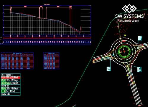
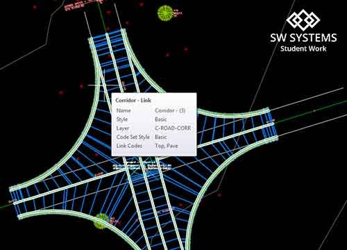
In this module, students will learn how to use Civil 3D for the design and documentation of highway projects. The focus will be on creating accurate surfaces, designing corridors, and preparing documentation necessary for highway engineering projects.
Key Topics:
- Introduction to Civil 3D Interface and Workflows
- Surface Creation: Importing and Managing Terrain Data
- Corridor Design: Creating and Modifying Highway Corridors
- Alignments and Profiles: Horizontal and Vertical Alignment Design
- Cross-Sections: Generating and Analysing Cross-Section Views
- Grading and Earthwork Calculations
- Documentation: Creating Plan Sheets and Quantities
Week 1: Introduction to Highway Design Principles
- Overview of highway design principles and standards.
- Introduction to the Civil 3D interface and workflows for highway design.
- Understanding site data: importing and managing terrain data for highway projects such as point data, LIDAR
data, point cloud data, etc. - Creating and managing surfaces: generating DTM (Digital Terrain Model) from survey data, setting up datum such
as WGS84. - Setting up alignment and profile styles for highway design.
Week 2: Corridor Design and Alignment
- Creating horizontal alignments for highway corridors and understanding design criteria.
- Creating vertical profiles to define the vertical alignment of the highway.
- Designing highway corridors using Civil 3D tools: linking alignments and profiles.
- Modifying corridor parameters and understanding the impact of design changes.
- Hands-on practice: Developing a basic highway corridor model.
Week 3: Grading and Earthwork Calculations
- Understanding grading design principles for highway projects.
- Utilizing grading tools in Civil 3D to create a smooth transition between surfaces.
- Conducting earthwork calculations for cut and fill volumes.
- Generating cross-sections for the highway corridor and analyzing material quantities.
- Hands-on practice: Applying grading techniques to refine the highway design.
Week 4: Documentation and Project Finalization
- Creating plan sheets for the highway design: annotation, labeling, and symbols.
- Generating reports for quantities and design specifications.
- Finalizing documentation: integrating feedback from project reviews and making necessary adjustments.
- Preparing a comprehensive presentation of the highway design project, including design rationale and key
metrics. - Course wrap-up: Q&A session, feedback, and discussion on next steps in professional development.
Module 2: Civil 3D for Pipe Network Designing
Duration: 1 Month
Key Topics:
- Introduction to Civil 3D Pipe Network Design
- Gravity Pipe Network Design: Modeling and Analyzing Gravity Systems
- Pressure Pipe Network Design: Creating Pressure Systems
- Creating and Managing Pipe Network Components
- Analyzing Pipe Network Flow and Sizing
- Generating Profile Views for Pipe Networks
- Documentation: Creating Plan Sheets and Quantity Take-offs
Week 1: Introduction and Basics of Pipe Networks
- Overview of Civil 3D and Pipe Network Design principles.
- Introduction to the Civil 3D interface and workspace.
- Understanding site data: importing and managing terrain data for Pipe Networks such as point data, LIDAR data, point cloud data, etc.
- Creating and managing surfaces: generating DTM (Digital Terrain Model) from survey data, setting up datum such as WGS84.
- Understanding the different types of pipe networks (Gravity and Pressure).
- Setting up a new Civil 3D project and importing base data (contours, existing utilities, etc.).
- Creating and editing pipe network styles and setting network properties.
Week 2: Gravity Pipe Network Design
- Principles and calculations involved in gravity pipe network design.
- Creating a gravity pipe network within Civil 3D, placement of pipe network structures such as inlets and manholes.
- Modifying and editing gravity pipe networks, with a focus on hydraulic grade lines (HGL) and energy grade lines (EGL).
- Conducting flow analysis and sizing for gravity systems, troubleshooting common issues.
Week 3: Pressure Pipe Network Design
- Introduction to pressure pipe network design principles and calculations.
- Creating a pressure pipe network in Civil 3D, incorporating pressure structures like valves and hydrants.
- Modifying and analyzing pressure pipe networks for efficiency and performance.
- Identifying and resolving issues related to pressure networks.
Week 4: Documentation and Project Finalization
- Creating profile views and generating cross-sections for pipe networks.
- Generating quantity take-offs and reports to document the designs.
- Final project setup, integrating gravity and pressure networks, and collaborating on designs.
- Preparing final documentation, exporting plans, and presenting the completed pipe network design project.
This module focuses on designing gravity and pressure pipe networks using Civil 3D. Students will gain skills in
modeling and analyzing pipe networks for various civil engineering applications, including water distribution,
stormwater management, and wastewater systems.
Choose Your Path
Participants can select one or both modules based on their professional focus.
- Single Module Duration: 1 Month
- Both Modules Duration: 1.5 Months
Why Learn Civil 3D?
By completing the Civil 3D Training, you will:
- Gain proficiency in civil engineering design using the latest software tools.
- Enhance your ability to design and document complex civil engineering projects.
- Improve efficiency in highway and pipe network design workflows.
- Prepare yourself for professional roles in civil engineering, site development, and infrastructure projects.
Benefits of Learning from SW Systems:
- Certificate – Autodesk Authorised Course Completion certificate (Accepted Globally)
- Trainer – Autodesk Certified Instructor
- Trainer qualification – B.E Civil with BIM training experience
This is a brief outline of the syllabus, if you want more details please visit our institute or call +919922960010.
Students Work
The Institute
Courses

